Kiri
| Dokumendiregister | Kultuuriministeerium |
| Viit | 14-4/6-1 |
| Registreeritud | 09.06.2025 |
| Sünkroonitud | 10.06.2025 |
| Liik | Sissetulev kiri |
| Funktsioon | 14 UNESCO-ga koostöö korraldamine |
| Sari | 14-4 UNESCO teadusprogrammide dokumendid |
| Toimik | 14-4/2025 UNESCO teadusprogrammide dokumendid |
| Juurdepääsupiirang | Avalik |
| Adressaat | UNESCO |
| Saabumis/saatmisviis | UNESCO |
| Vastutaja | Madli Kumpas (KULTUURIMINISTEERIUM, UNESCO ERK) |
| Originaal | Ava uues aknas |
| Taotle dokumendi eemaldamist või parandamist |
Failid
From: Man & Biosphere <[email protected]>
Sent: Fri, 06 Jun 2025 19:34:33 +0000
To: Toomas Kokovkin <[email protected]>; Delegation of Estonia/Délégation d'Estonie <[email protected]>; "NAC contact - Estonian National Commission for UNESCO (UNESCO Eesti Rahvuslik ; National Commission" <[email protected]>
Cc: "Dodds; Carrie Delayne" <[email protected]>; "Thulstrup; Hans" <[email protected]>; "Heckler; Serena" <[email protected]>
Subject: [Estonia] Request for biosphere reserve shapefiles
Man and the Biosphere Programme: Technical guidance for creating zonation shapefiles for Biosphere Reserves
About biosphere reserve spatial data New and existing Biosphere Reserves are expected to include the latest zonation map and accompanying shapefiles when submitting the Nomination Form and Periodic Reviews.
These files are shared and maintained in a publicly accessible electronic map and spatial database that can be used for monitoring and analysis.
The guidance that follows outlines the Man and the Biosphere programme’s requirements for spatial data as well as recommended approaches for creating shapefiles using common GIS software. This document serves as a complement to the Technical Guidelines for Biosphere Reserves.
Requirements
Zonation and boundaries
• The shapefile should be based on the most recently MAB-ICC approved biosphere reserve zonation map, submitted with either the periodic review or, for newly designated biosphere reserves, the nomination form. The map must be produced at an appropriate scale to ensure the precision of the layers and accurate representation of the boundaries.
• There should be no spatial ring self-intersections (a polygon line that crosses itself in a bowtie or figure-eight fashion), overlays (zones overlapping one another), gaps (empty spaces between zones), or unclosed rings (a polygon boundary that does not fully close).
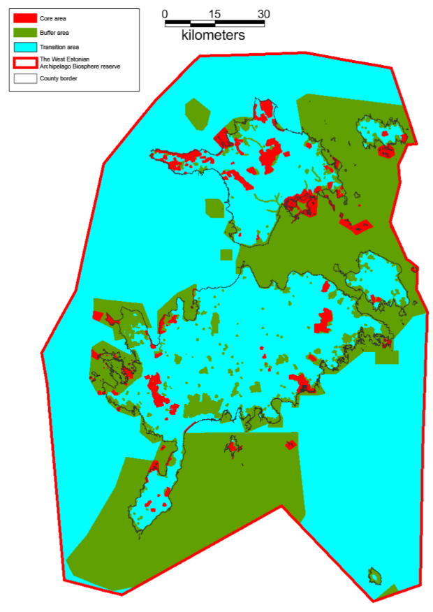
Image: Example of correct zonation map free of gaps and spatial overlays
• Spatial disturbances, such as sliver polygons (small polygons found in vector data that are artifacts of error rather than representing a real-world feature) should be removed from the final file before submissions.
• All zones should respect national borders and any natural or artificial delineating structures.
Settings
• Layers should use the coordinate reference system (CRS) WGS 84 World Geodetic System (EPSG: 4326). Local coordinate systems are also allowed, but the projection should be encoded in the file and information on the local coordinate system used provided with the data.
• The shapefile should be comprised of three polygons – one each for the core area(s), buffer zone(s), and transition area(s) – that cover the entire area of the biosphere reserve.
• The attribute table must clearly and comprehensibly describe the zonation polygons, using the labels “Core”, “Buffer”, and “Transition”.
Image: Example of an attributes table with correct zonation labels
File types
• Data can be submitted in any standard GIS file format (OGC GML, GeoJSON, etc.), though ESRI shapefiles (.shp) compressed as a single .zip or .rar file are preferred.
• ESRI shapefiles should be submitted as a single .zip or .rar file per biosphere reserve, including all linked .shp, .shx, .dbf, and .prj files for each layer.
.png)